Tocht Te voet Druelle Balsac - Ampiac (région de Rodez) - Photo

Ampiac (région de Rodez)

 Delahalle
Delahalle

Gebruiker

© OpenStreetMap contributors
Lengte
Lengte
10,1 km
Max. hoogte
Max. hoogte
638 m
Positief hoogteverschil
336 m
Km-Effort
Km-Effort  
14,6 km
Min. hoogte
Min. hoogte
482 m
Negatief hoogteverschil
336 m
Boucle
Boucle
Ja
Datum van aanmaak :
2020-08-16 16:16:12.974
Laatste wijziging :
2020-08-16 16:21:28.1

(0 Bericht)

Te voet
Te voet
--
Moeilijkheid : Medium

Scan deze QR-code om de tocht te openen in de SityTrail-applicatie

Gratisgps-wandelapplicatie

Logo SityTrail SityTrail

IGN / Geografische instituten

SityTrail uit de App Store downloaden SityTrail uit Google Play downloaden

Logo SityTrail SityTrail World

De wereld gaat voor u open

SityTrail uit de App Store downloaden SityTrail uit Google Play downloaden SityTrail op Huawei AppGallery downloaden

Over ons

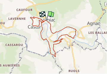
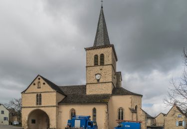
Tocht Te voet van 10,1 km beschikbaar op Occitanië, Aveyron, Druelle Balsac. Deze tocht wordt voorgesteld door Delahalle.

Beschrijving

Une randonnée avec de beaux points de vue sur cette partie de la vallée de l'Aveyron. Final avec le chemin de croix. Ne pas rater juste après le système de prise d'eau pour le village le petit chemin étroit à gauche qui remonte jusqu'au parking du point de départ Place du château. Comme souvent, plusieurs chemins, pourtant parfois très anciens, ne figurent pas sur la carte IGN, mais existent bel et bien sur le terrain.
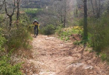
Hoogteprofiel

Plaatsbepaling

Land:
France
Regio :
Occitanië
Departement/Provincie :
Aveyron
Gemeente :
Druelle Balsac
Locatie:
Unknown
Vertrek:(UTM)
459553 ; 4910309 (31T) N.

Wandeltochten in de omgeving

Tocht Mountainbike Druelle Balsac - Autour de l'Aveyron de Agnac à Ampiac - Photo
Mountainbike
tracegps

Mountainbike

Zeer moeilijk
(1)
Druelle Balsac, Occitanië, Aveyron, France
15,7 km | 24 km-effort
3h 45min
Ja
Tocht Te voet Luc-la-Primaube - Circuit 9 Planèzes - Photo
Te voet
PRO

Te voet

Gemakkelijk
Luc-la-Primaube, Occitanië, Aveyron, France
8,8 km | 11,5 km-effort
2h 37min
Ja
Tocht Te voet Olemps - Circuit 8 Le Viel Olemps - Photo
Te voet
PRO

Te voet

Gemakkelijk
Olemps, Occitanië, Aveyron, France
5,1 km | 6,5 km-effort
1h 29min
Ja
Tocht Te voet Druelle Balsac - Le Cirque du Sauvage - Photo
Te voet
PRO

Te voet

Gemakkelijk
Druelle Balsac, Occitanië, Aveyron, France
8,2 km | 12,1 km-effort
2h 45min
Ja
Tocht Stappen Moyrazès - Moyrazės - Photo
Stappen
tercla

Stappen

Moeilijk
Moyrazès, Occitanië, Aveyron, France
18,8 km | 27 km-effort
4h 57min
Ja
Tocht Te voet Druelle Balsac - Circuit 4 Saint-Clément - Photo
Te voet
PRO

Te voet

Gemakkelijk
Druelle Balsac, Occitanië, Aveyron, France
7 km | 10,4 km-effort
2h 22min
Ja
Tocht Te voet Druelle Balsac - Circuit 22 Le château d'Is - Photo
Te voet
PRO

Te voet

Gemakkelijk
Druelle Balsac, Occitanië, Aveyron, France
9,5 km | 11,2 km-effort
2h 32min
Ja
Tocht Te voet Olemps - Circuit 6 Toizac - Photo
Te voet
PRO

Te voet

Gemakkelijk
Olemps, Occitanië, Aveyron, France
3,1 km | 4,4 km-effort
59min
Ja
Tocht Te voet Druelle Balsac - Circuit 5 Ampiac - Photo
Te voet
PRO

Te voet

Gemakkelijk
Druelle Balsac, Occitanië, Aveyron, France
4,1 km | 5,3 km-effort
1h 11min
Neen


Sluiten
Mijn abonnementen